


 Tweet
Tweet
Quick Links
Day 0 - Nainital to Didihat
Day 1 - Didihat to Dantu
Day 2 - Dantu
Day 3 - Dantu to Munsyari
Day 4 - Munsyari to Lohaghat
Day 5 - Lohaghat to Nainital (end of ride)
------------
Day 0 - Nainital to Didihat
Darma Valley was a relatively new destination for me. I heard about it only a couple of years back and didn't pay much attention to it at that time. However, I do remember long ago when I was in Munsiyari wondering wondered what lied on the other other side of the Panchachuli mountains.
Day 0 - Nainital to Didihat
Day 1 - Didihat to Dantu
Day 2 - Dantu
Day 3 - Dantu to Munsyari
Day 4 - Munsyari to Lohaghat
Day 5 - Lohaghat to Nainital (end of ride)
------------
Day 0 - Nainital to Didihat
Darma Valley was a relatively new destination for me. I heard about it only a couple of years back and didn't pay much attention to it at that time. However, I do remember long ago when I was in Munsiyari wondering wondered what lied on the other other side of the Panchachuli mountains.
Anyway, all of that changed when I saw a few posts on the net about the Darma valley and the breathtaking views of the Panchachuli. So when the opportunity around in Oct 2019, I decided to take a short bike ride.
Reaching Nainital on Oct 15th, plan was to leave on Oct 16th for a 6 day ride.
 Day 0 map - Nainital to Didihat
 When I left Nainital early in the morning, the weather was beautiful. Much like one would expect an autumn morning.

My trusted Honda Trigger next to the lake in Mallital, while sun rises off at the other end of the lake.
It was somewhat cold, colder than usual for Oct. I hoped things would get warmer once the sun rose.

Sunrise over the ridge on Nainital-Bhowali Road

Moon setting behind the hills near Ratighat
My plan for the 1st day was to cover significant distance. So without stopping much I covered a lot of miles. Kainchi, Ratighat, Garam pani and Khairna went by soon.
Post Khairna, I turned right towards Almora and stopped for a short break to stretch my legs.The road leading up to Almora from Khairna is through the picturesque valley of Kosi River. The valley starts narrow and then widen up to a series of villages flanked by terraced fields. Early autumn is a time is changing colors. The leaves start changing colors and then slowly wither and fall away to form fertile compost for the growth of next year. At this time the forest presents a potpourri of hues.

Wild flowers with the colorful hillside at the back.

Another naturally framed picture of the autumn colors.

My ride amidst the hues of autumn
Having left Khairna behind, the climb to Almora had just began. The valley was quite narrow at this point presenting a close view of the hills on both side of the river.
Post rains, wild flowers were abundant, soon to be withered by the onslaught of winter cold.
Kosi River gurgling though the narrow valley
By now the clouds had gathered on the horizon. While I was not worried about the rain, I was concerned about the view of snowy peaks being blocked.
The visibility was somewhat poor and the last stretch of the climb to Almora was white washed by fog. At the first viewpoint, which lies around 9Km before Almora and has the first glimpse of the Trishul peaks none of the snowy peaks were visible.
Soon I was at Almora and took the bypass towards Barechhina. The roads at Almora tend to get crowded and I had no wish to get stuck behind some bus in the narrow city roads.

City of Almora with the clouds below the city
The sky ahead was a little better, though hazy. I had my first glimpse of the snowy peaks at Chitai Temple.

Trishul and Mrigthuni Peaks from Chitai Temple

Temple bells lined up for sale outside Chitai temple
Beyond the Chitai temple, the beautiful pine jungle starts. These is my favorite jungle type to drive through. Ahh!! the smell of the pines which was immortalized by Kipling.

In the shadow of the Pines

Kids walking from their village to school in Barechhina

Main street of DhaulaChhina
Having had nothing from morning other than a cup of tea, I was ready to devour anything. Stopping at a tea shop in DhaulaChhina, I sat down for a bun-omlette and tea.

Omlette preparations
A full stomach makes the ride easier. One stops worrying about the pacifying the grumbling stomach and starts appreciating the surrounding. Fortunately the road first descends to Seraghat and then climbs up to Berinag though some beautiful hillside and valleys.
My back of mind calculations told me that I was running ahead of schedule. So I stopped often both for pictures and to rest my butt.
Another view of the snowy mountain on the way down to Seraghat
Seraghat is a small town on the banks of Saryu river. Other than the lush green surroundings and the Saryu river, the only other thing that separated this small town from many others is the large iron bridge.

Saryu river at Seraghat
After Seraghat, the road flanks the Saryu for a while and then ascends towards Berinag though another stretch of magnificent pines.

A cast iron bridge over Saryu River
The sun had been out for quite some time now and it was balmy warm. Stopping for a break, I sat down to enjoy the warmth of the sun and the smell of the pines.
To my surprise the silence was deafening. While I did appreciate absence of traffic and other man-made noise, I was surprised that there were no birds chirping. Perhaps they too had dozed off in the noon sun. Even the sound of the wind whispering to the leaves was missing.
A selfie before taking off the gear and snoozing on the side of the road.
Wanting to stretch my legs, I left my bike on the side of the road and climbed up the hillside, following a thin cattle trail. Walking on the thin cushion of pine needles was like a soft massage to the feet. In hindsight, I should probably have taken my shoes off and enjoyed the feeling.

View from up in the mountain side

Fern amidst the pines
Soon I was at Berinag where I found a bypass which circumvented the city. At the other end I tanked up at a petrol station and then moved towards Thal.
The route down towards Thal, starts a few Km before Chaukori which is another excellent hill station in Kumaon. Over the first few Km the road crosses several villages with fields flanking the road. These are then replaced by dense pine jungle.As the road approaches Thal, the jungle and the nice road is replaced by broken tar and garbage of the city welcoming you into the town of Thal.
Thal is a small town on the banks of Ramganga river. It is a junction point of four roads which lead to Berinag/Almora (where I was coming from), Didihat (where I was going), Munsiyari/Bageshwar and Pithoragarh.
There used to be a big mela that was held at Thal. Not sure whether it is still held or not.

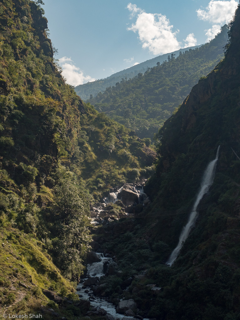
A waterfall on Thal-Didihat road
Beyond Thal I turned towards Didihat and the road condition also deteriorated. The jungle and the greenery continued to be fascinating.

More ferns and pine.
For some reason I had false hopes that the road up to Didihat from Thal would provide me with marvelous view of the snow capped Himalayas. However that was not to be. The roads is mostly on the sheltered side of the hill with a smaller hills and peaks between the road and the snow capped Panchachuli.

Another waterfall on way to Didihat
At Didihat, I checked in to the KMVN TRC which fortunately I had booked previously. The place was otherwise full of election officials - Uttarakhand was having gram panchayat election on that day.
After a double cup of tea and maggi, I stepped out to check out the Shirakot temple which is located a little way from the town. However, the road was in pretty horrible condition. So I decided to skip the temple.
View of the town of Didihat from a distance

Shirakot temple from where I turned back.

KMVN TRC
Returning back to TRC, I wandered around the town taking in the feel of small town market. A simple dinner at the TRC mess and I was off to sleep.
Pictures from next day:

Highest peak of Panchachuli from Didihat

Moonlit Panchachuli


Comment